Placer Mountain
Gold Project

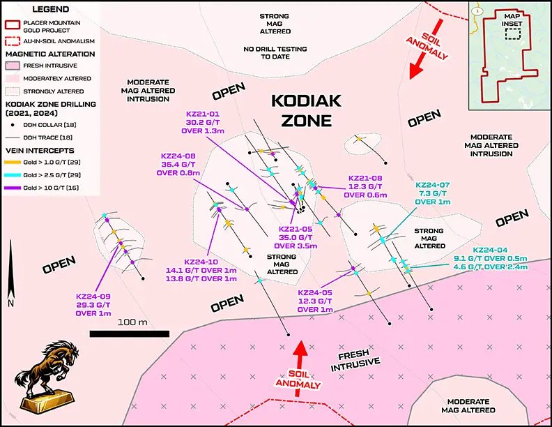
The Kodiak Zone shows strong potential, with near-surface gold grades up to 40 g/t Au and gold intersected in every drill hole across an expanding zone

Established Mining Camp

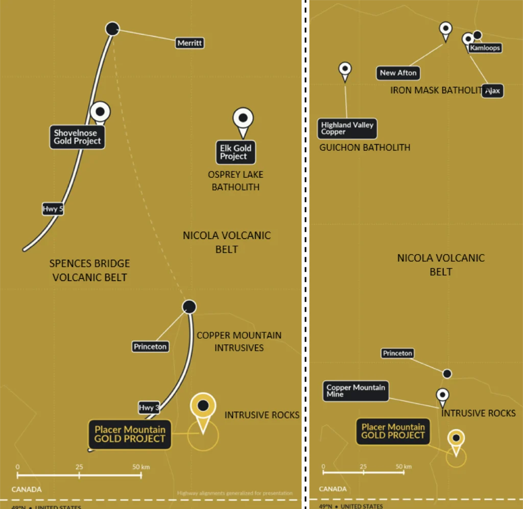
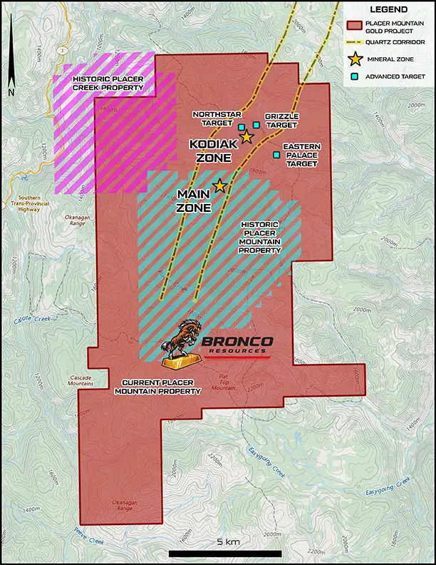
Spanning 17,037 hectares just 30 km south of Princeton, BC, this highly prospective property lies near the southern extent of the gold-bearing Nicola Group. The Kodiak Zone has returned near-surface grades of 40 g/t Au over 3 metres, with mineralization drill-tested across a 300 m by 300 m area. With a multi-year area-based permit in place, newly acquired claims, and multiple emerging targets supported by extensive 2026 exploration work, the project is positioned for further drilling and discovery.

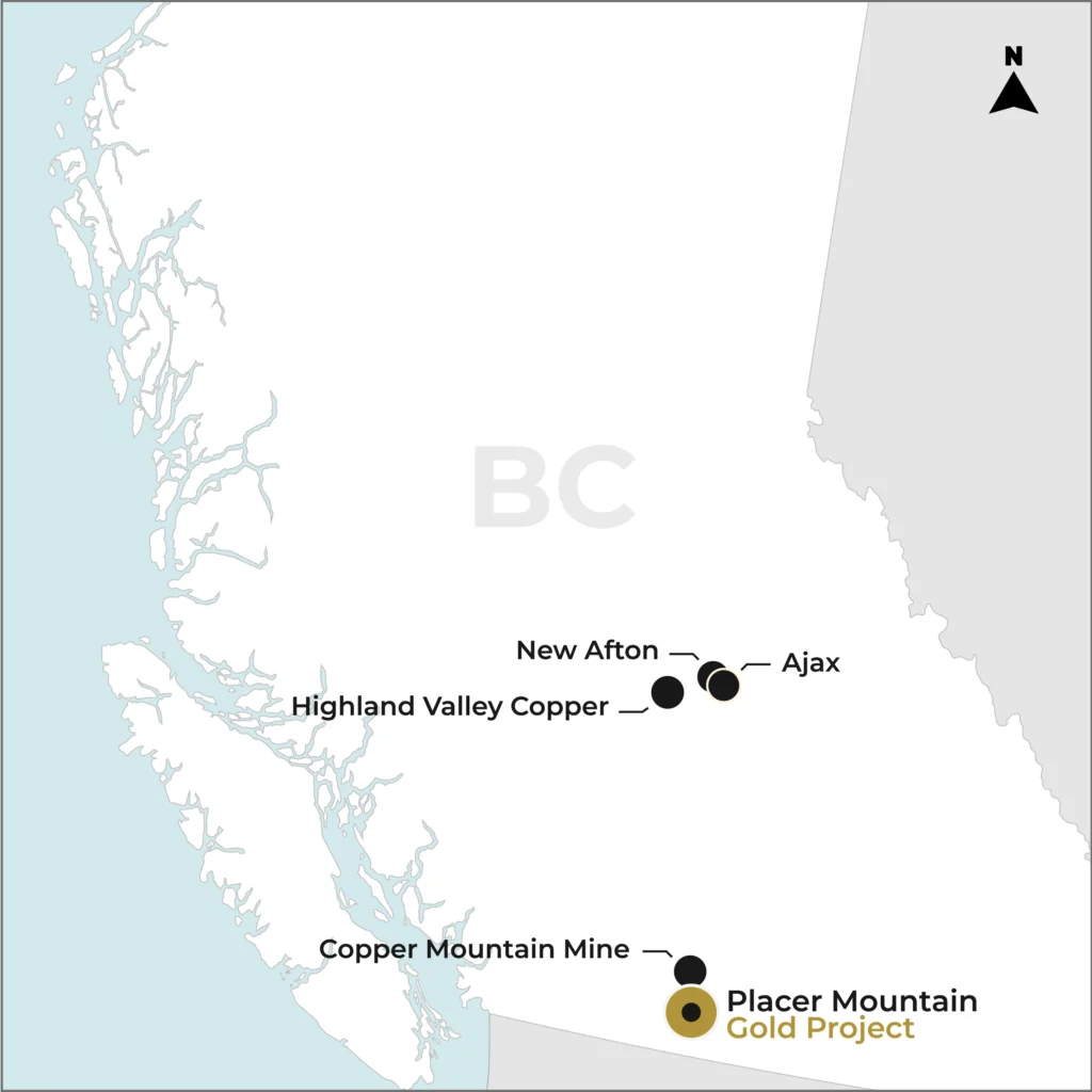
South-Central BC Mining District

  • Three producing mines: New Afton, Highland Valley, Copper Mountain
  • Established mining corridor with active production
  • Large scale infrastructure, multiple targets

Promising Geological Setting

The property has significant potential to host a large-scale orogenic gold system, with the Kodiak and Main Zones situated 2.5 km apart along a geological contact between the Nicola Group and granitic intrusions. This setting is comparable to the Elk Gold Project, a past producer located approximately 70 km north, which hosts mesothermal gold veins in a similar geological environment. The region is also home to established mines, including New Afton, Copper Mountain and HVC.

KODIAK ZONE

40 g/t Au over 3 m

MAIN ZONE

217 g/t Au sampled

From An MMI Anomaly To 217 g/t Au

First Phase Exploration at Placer

First Systemic Work -MMI Survey

Sydney Wilson initiates soil geochemistry at Placer Mountain, identifying a significant multi-element anomaly while targeting a concealed porphyry Cu-Mo system.

Gold Changes the Model

Follow-up MMI surveys identify a strong Au-Ag-Cu-Mo anomaly, while prospecting uncovers quartz float grading up to 21 g/t Au, shifting exploration toward high-grade vein-hosted gold.

Main / Wilson Zone Emerges

Windfire Capital identifies high-grade gold, with 13 of 36 rock samples exceeding 10 g/t Au and reaching 66.2 g/t Au, alongside parallel soil anomalies extending 650 m.

Strong Clues, Limited Follow-Up

Mapping and sampling confirm gold-copper mineralization in Nicola Group rocks, with quartz float grading up to 25.3 g/t Au and soil anomalies extending north of Area 2, laying the groundwork for the Quartz Corridor target.

2024 | Kodiak Zone Phase 2 Drilling Expands High-Grade Gold

The 2024 Phase 2 drilling program extended high-grade gold mineralization along strike, with all 10 diamond drill holes intersecting gold and the mineralized footprint expanding to approximately 300 × 300 m. Results included 0.80 m at 36.40 g/t Au and 13.10 m at 2.28 g/t Au. Despite strong results, limited structural data, core orientation and geophysical targeting left significant opportunities to refine the geological model and guide future exploration.

2026 | A New Paradigm: Building the Exploration Model

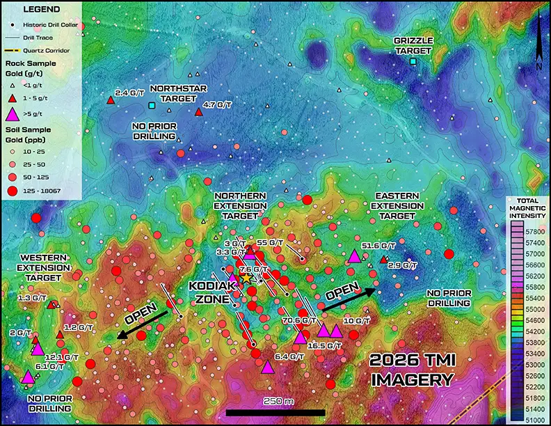
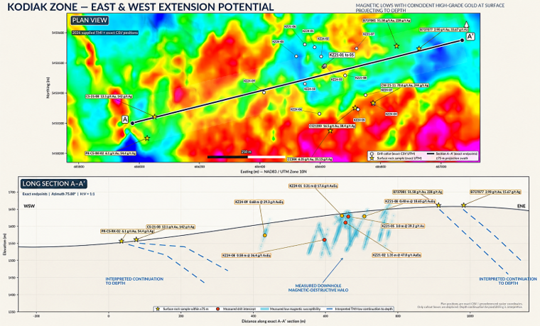
Bronco completed 450 line-km of high-resolution ground magnetics and re-evaluated 1,961 m of historic drill core, identifying distinct mineralization styles. The results differentiated magnetite-rich mineralization from later, weakly magnetic gold associated with quartz veining and chalcopyrite, creating a refined framework for future exploration targeting.

Magnetic Phase (I)

9.11 g/t Au
Strong magnetic response
Interstitial black magnetite
143 x 10-3 K SI response

Non-Magnetic Phase (II)

17.60 g/t Au
Weak magnetic response
Chalcopyrite (Cu) bearing phase
0.05 - 0.25 x 10⁻³ K SI response

New Phase (III)

Blue quartz phase
First recognized in 2026
Lack of sulfide minerals
Very low iron content
51.6 g/t Au east of Kodiak

Building The Exploration Model

Bronco completed the Project’s most comprehensive modern surface exploration program, combining 2,500 hectares of LiDAR coverage, 1,011 soil samples and extensive prospecting. Results included soil values up to 334 ppb Au, a new outcrop grading 55.03 g/t Au and 149 g/t Ag north of Kodiak, and gold-bearing quartz grading up to 6.43 g/t Au south of the zone. Blue quartz returning up to 51.6 g/t Au revealed an additional mineral phase.

55.03 g/t Au discovered north of Kodiak.

the big picture

Kodiak Expansion And Beyond

Integrated Targeting

LiDAR, soil geochemistry, rock sampling and detailed magnetics combine to identify priority targets where gold anomalies, structures and magnetic features overlap.

Mapping Concealed Geology

2026 mapping better defines younger Princeton Group basalt cover east of Kodiak, where prospective rocks may be concealed and surface geochemical signals reduced.

Potential Beneath the Cover

Gold and pathfinder anomalies persist beneath basalt-covered terrain, suggesting potential for mineralization beyond exposed areas.

From Discovery to District-Scale

The 2026 program expanded exploration beyond Kodiak, establishing an integrated framework to target exposed and concealed extensions of the gold system.